IMAGES TAKEN NEAR TO
Byrne Road, SNODLAND, ME6 5FY
Introduction
This page details the photographs taken nearby to Byrne Road, ME6 5FY by members of the Geograph project.
The Geograph project started in 2005 with the aim of publishing, organising and preserving representative images for every square kilometre of Great Britain, Ireland and the Isle of Man.

There are currently over 7.5m images from over14,400 individuals and you can help contribute to the project by visiting https://www.geograph.org.uk
Image Map
Images are licensed for reuse under creativecommons.org/licenses/by-sa/2.0
Notes
- Clicking on the map will re-center to the selected point.
- The higher the marker number, the further away the image location is from the centre of the postcode.
Image Listing (8 Images Found)
Images are licensed for reuse under creativecommons.org/licenses/by-sa/2.0
Image
Details
Distance
1
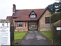
Entrance to Snodland Cemetery
At end of Cemetery Road. Chapel of Rest on right-hand side of cemetery lodge.
Image: © David Anstiss
Taken: 12 Dec 2008
0.16 miles
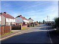
2
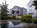
Houses on Poynder Drive
Part of the Holborough Lakes development. Built on a former Tarmac cement quarry site.
Houses styled after the New England timber-framed buildings.
Image: © David Anstiss
Taken: 23 May 2017
0.16 miles
3
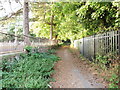
Whitedyke Road, Snodland
Snodland cemetery is on the left.
Image: © Chris Whippet
Taken: 19 Aug 2013
0.17 miles
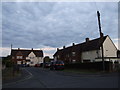
4
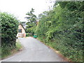
Cemetery Road, Snodland
The cemetery is on the left, whilst the byway Whitedyke Road is on the right.
Image: © Chris Whippet
Taken: 14 Jul 2010
0.18 miles
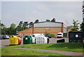
5
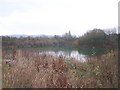
Woodlands Lake, Snodland
On Cemetery Road. Used by Medway Valley Fisheries. Membership and day ticket fishing. On land owned by Berkeley Homes.
Image: © David Anstiss
Taken: 12 Dec 2008
0.23 miles