IMAGES TAKEN NEAR TO
Constitution Hill, SNODLAND, ME6 5ED
Introduction
This page details the photographs taken nearby to Constitution Hill, ME6 5ED by members of the Geograph project.
The Geograph project started in 2005 with the aim of publishing, organising and preserving representative images for every square kilometre of Great Britain, Ireland and the Isle of Man.

There are currently over 7.5m images from over14,400 individuals and you can help contribute to the project by visiting https://www.geograph.org.uk
Image Map
Images are licensed for reuse under creativecommons.org/licenses/by-sa/2.0
Notes
- Clicking on the map will re-center to the selected point.
- The higher the marker number, the further away the image location is from the centre of the postcode.
Image Listing (113 Images Found)
Images are licensed for reuse under creativecommons.org/licenses/by-sa/2.0
Image
Details
Distance
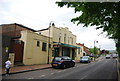
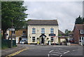
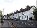
3
The Monk's Head Pub, Snodland
On junction of Birling Road and Constitution Hill.
Image: © David Anstiss
Taken: 12 Dec 2008
0.04 miles
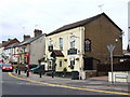
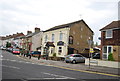
10
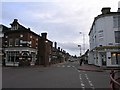
Snodland Town Centre
Snodland town centre has changed little since the 1920s, save for modern railings road signs and some incredibly unsightly CCTV poles. Even the bakery still sports the Hovis logo, which could be observed on a period post card.
Image: © Hywel Williams
Taken: 28 Mar 2006
0.05 miles