IMAGES TAKEN NEAR TO
Bramley Road, SNODLAND, ME6 5DY
Introduction
This page details the photographs taken nearby to Bramley Road, ME6 5DY by members of the Geograph project.
The Geograph project started in 2005 with the aim of publishing, organising and preserving representative images for every square kilometre of Great Britain, Ireland and the Isle of Man.

There are currently over 7.5m images from over14,400 individuals and you can help contribute to the project by visiting https://www.geograph.org.uk
Image Map
Images are licensed for reuse under creativecommons.org/licenses/by-sa/2.0
Notes
- Clicking on the map will re-center to the selected point.
- The higher the marker number, the further away the image location is from the centre of the postcode.
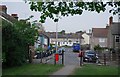
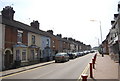
Image Listing (90 Images Found)
Images are licensed for reuse under creativecommons.org/licenses/by-sa/2.0
Image
Details
Distance
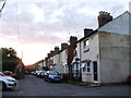
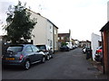
5

Row of houses at the entrance to Recreation Ground, Snodland
Image: © Chris Whippet
Taken: 19 Aug 2013
0.05 miles

9
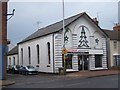
Converted Methodist Church, Snodland
On junction of Malling Road and Chapel Road.
Primitive Methodist Church converted into Corvette Car Specialists. Has engraved window at rear, which shows it's previous life. Built in 1900.
Image: © David Anstiss
Taken: 12 Dec 2008
0.06 miles