IMAGES TAKEN NEAR TO
Tom Joyce Close, SNODLAND, ME6 5BT
Introduction
This page details the photographs taken nearby to Tom Joyce Close, ME6 5BT by members of the Geograph project.
The Geograph project started in 2005 with the aim of publishing, organising and preserving representative images for every square kilometre of Great Britain, Ireland and the Isle of Man.

There are currently over 7.5m images from over14,400 individuals and you can help contribute to the project by visiting https://www.geograph.org.uk
Image Map
Images are licensed for reuse under creativecommons.org/licenses/by-sa/2.0
Notes
- Clicking on the map will re-center to the selected point.
- The higher the marker number, the further away the image location is from the centre of the postcode.
Image Listing (51 Images Found)
Images are licensed for reuse under creativecommons.org/licenses/by-sa/2.0
Image
Details
Distance
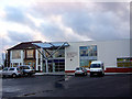
1
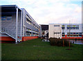
Holmesdale Technology College, Snodland
As seen from the playing fields, this is part of the new build at Holmesdale. On the left are the Maths and Science classrooms, while on the right are Languages, Art and Design and Technology.
Image: © Richard Dorrell
Taken: 21 Jan 2008
0.07 miles
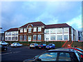
4
Holmesdale Technology College, Snodland
Originally built as Saint Katherine's Primary School, this building, now called "Wolfe Building", has been part of Holmesdale Technology College for many years. Following the complete rebuild of Holmesdale, Wolfe is currently being used by Adult Education for day and evening classes.
Image: © Richard Dorrell
Taken: 21 Jan 2008
0.08 miles
5
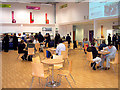
Holmesdale Technology College, Snodland
This is the canteen at lunchtime. The canteen and library are open to the public. Were school dinners like this when you were at school?
Image: © Richard Dorrell
Taken: 21 Jan 2008
0.10 miles
6
Holmesdale Technology College, Snodland
This classic 1930's facade, called the Howard Building, is all that remains of the "old" Holmesdale School. This building has recently been gutted internally, and refurbished and extended to provide 21st century school accommodation.
Image: © Richard Dorrell
Taken: 21 Jan 2008
0.10 miles
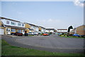
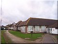
10
Holmesdale Technology College, Snodland
Old meets new - on the left is the 1930's "Howard Building", on the right is part of the new school - the library, offices and classrooms upstairs, hall and canteen downstairs. The OS map gridline cuts directly through this facade...!
Image: © Richard Dorrell
Taken: 21 Jan 2008
0.13 miles