IMAGES TAKEN NEAR TO
East Street, SNODLAND, ME6 5BA
Introduction
This page details the photographs taken nearby to East Street, ME6 5BA by members of the Geograph project.
The Geograph project started in 2005 with the aim of publishing, organising and preserving representative images for every square kilometre of Great Britain, Ireland and the Isle of Man.

There are currently over 7.5m images from over14,400 individuals and you can help contribute to the project by visiting https://www.geograph.org.uk
Image Map
Images are licensed for reuse under creativecommons.org/licenses/by-sa/2.0
Notes
- Clicking on the map will re-center to the selected point.
- The higher the marker number, the further away the image location is from the centre of the postcode.
Image Listing (147 Images Found)
Images are licensed for reuse under creativecommons.org/licenses/by-sa/2.0
Image
Details
Distance
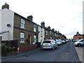

9
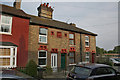
Faith Place
The ornate terracotta lintels are an exceptional feature. The plaque gives the date of this group as 1871, making this an early use of decorative terracotta.
Image: © Alan Murray-Rust
Taken: 1 May 2011
0.04 miles