IMAGES TAKEN NEAR TO
Warren Road, CHATHAM, ME5 9RF
Introduction
This page details the photographs taken nearby to Warren Road, ME5 9RF by members of the Geograph project.
The Geograph project started in 2005 with the aim of publishing, organising and preserving representative images for every square kilometre of Great Britain, Ireland and the Isle of Man.

There are currently over 7.5m images from over14,400 individuals and you can help contribute to the project by visiting https://www.geograph.org.uk
Image Map
Images are licensed for reuse under creativecommons.org/licenses/by-sa/2.0
Notes
- Clicking on the map will re-center to the selected point.
- The higher the marker number, the further away the image location is from the centre of the postcode.
Image Listing (41 Images Found)
Images are licensed for reuse under creativecommons.org/licenses/by-sa/2.0
Image
Details
Distance
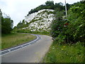
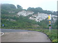
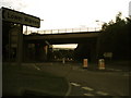
2
Blue Bell Hill
This is the view looking up the turn off from the busy A229 which is the newer version of Blue Bell Hill and shows how the road has been cut down through the chalk. Blue Bell Hill is the name given to the part of the North Downs here as well as the hill on the A229. Lower warren Road is on the right.
Image: © Marathon
Taken: 1 Aug 2012
0.07 miles
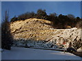
3
The chalk cliff of Blue Bell Hill
This is the view looking along the turn off from the busy A229 which is the newer version of Blue Bell Hill. Blue Bell Hill is the name given to the part of the North Downs here as well as the hill on the A229.
Image: © Marathon
Taken: 1 Aug 2012
0.07 miles
4
Cliff overlooking A229 slip road, Blue Bell Hill
Image: © Chris Whippet
Taken: 19 Dec 2009
0.08 miles
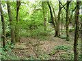
5
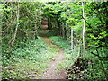
Steep woodland footpath near Blue Bell Hill
Image: © Chris Whippet
Taken: 12 Jun 2009
0.09 miles
6
Cliff Overlooking A229 Bluebell Hill
Picture taken from Shell Garage on the northbound side, on a drizzly evening. The milky blurring in the top left corner is actually low cloud.
Image: © Danny P Robinson
Taken: 9 Jul 2008
0.10 miles
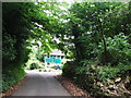
7
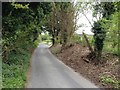
Lower Warren Road, near Blue Bell Hill
Image: © Chris Whippet
Taken: 21 Apr 2017
0.11 miles
8
Lower Warren Road, near Blue Bell Hill
Image: © Chris Whippet
Taken: 19 Dec 2009
0.12 miles
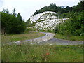
10
Old pit by Warren Road
The 1896 map calls this a clay pit, and the 1876 map does not show it, which is some indication of when it was dug.
Image: © Robin Webster
Taken: 23 Jun 2012
0.12 miles