IMAGES TAKEN NEAR TO
Hawthorns, CHATHAM, ME5 9DS
Introduction
This page details the photographs taken nearby to Hawthorns, ME5 9DS by members of the Geograph project.
The Geograph project started in 2005 with the aim of publishing, organising and preserving representative images for every square kilometre of Great Britain, Ireland and the Isle of Man.

There are currently over 7.5m images from over14,400 individuals and you can help contribute to the project by visiting https://www.geograph.org.uk
Image Map
Images are licensed for reuse under creativecommons.org/licenses/by-sa/2.0
Notes
- Clicking on the map will re-center to the selected point.
- The higher the marker number, the further away the image location is from the centre of the postcode.
Image Listing (39 Images Found)
Images are licensed for reuse under creativecommons.org/licenses/by-sa/2.0
Image
Details
Distance
7
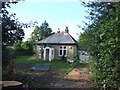
Bungalow, Tunbury Avenue, Walderslade Woods
It looks like this recently vacated bungalow is likely to be demolished and the plot redeveloped.
Image: © Chris Whippet
Taken: 17 Sep 2010
0.09 miles
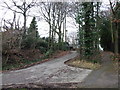
10
Entrance to Walderslade Woods
As seen from Tunbury Avenue South.
This woodland track leads down to the valley bottom footpath.
Image: © David Anstiss
Taken: 14 Oct 2012
0.10 miles