IMAGES TAKEN NEAR TO
Chatham Hill, CHATHAM, ME5 7AN
Introduction
This page details the photographs taken nearby to Chatham Hill, ME5 7AN by members of the Geograph project.
The Geograph project started in 2005 with the aim of publishing, organising and preserving representative images for every square kilometre of Great Britain, Ireland and the Isle of Man.

There are currently over 7.5m images from over14,400 individuals and you can help contribute to the project by visiting https://www.geograph.org.uk
Image Map
Images are licensed for reuse under creativecommons.org/licenses/by-sa/2.0
Notes
- Clicking on the map will re-center to the selected point.
- The higher the marker number, the further away the image location is from the centre of the postcode.
Image Listing (193 Images Found)
Images are licensed for reuse under creativecommons.org/licenses/by-sa/2.0
Image
Details
Distance
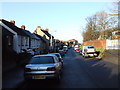
3
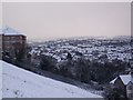
View of the Capstone Valley
Seen from the footpath on the Great Lines. Looking up towards Darland. Samuels Tower is on the left.
Image: © David Anstiss
Taken: 7 Jan 2010
0.02 miles
6
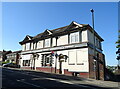
Former White Horse public house on Chatham Hill
Image: © JThomas
Taken: 22 Jun 2022
0.03 miles
7
Domino's Pizza, junction of Chatham Hill, A2 & Whitehorse Hill
Image: © N Chadwick
Taken: 31 Jan 2009
0.04 miles
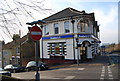
8

The White Horse, Chatham
A former pub now used as a fast food delivery unit.
Image: © Chris Whippet
Taken: 11 Jun 2010
0.04 miles
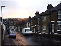
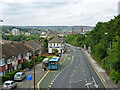
10
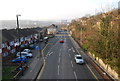
A2, Chatham Hill, looking NW towards Chatham
Image: © N Chadwick
Taken: 31 Jan 2009
0.04 miles