IMAGES TAKEN NEAR TO
Walderslade Road, CHATHAM, ME5 0LT
Introduction
This page details the photographs taken nearby to Walderslade Road, ME5 0LT by members of the Geograph project.
The Geograph project started in 2005 with the aim of publishing, organising and preserving representative images for every square kilometre of Great Britain, Ireland and the Isle of Man.

There are currently over 7.5m images from over14,400 individuals and you can help contribute to the project by visiting https://www.geograph.org.uk
Image Map
Images are licensed for reuse under creativecommons.org/licenses/by-sa/2.0
Notes
- Clicking on the map will re-center to the selected point.
- The higher the marker number, the further away the image location is from the centre of the postcode.
Image Listing (30 Images Found)
Images are licensed for reuse under creativecommons.org/licenses/by-sa/2.0
Image
Details
Distance

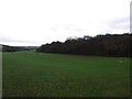
4
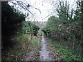
Footpath to Snodhurst Bottom from Magpie Hall Road
Image: © Chris Whippet
Taken: 18 Dec 2013
0.07 miles
5
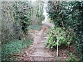
Steps leading up to Magpie Hall Road from Snodhurst Bottom
Image: © Chris Whippet
Taken: 18 Dec 2013
0.08 miles
8
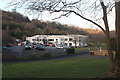
The Park Club, Snodhurst Bottom, Chatham
Formerly known as Fitness First.
Image: © Richard Gadsby
Taken: 8 Feb 2015
0.11 miles
9
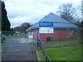
Snodhurst Bottom Pitch and Putt
Off Walderslade Road. Run by Medway Council.
Beside Fitness First Health Club on left.
Image: © David Anstiss
Taken: 20 Nov 2008
0.13 miles
