IMAGES TAKEN NEAR TO
Rowan Lea, CHATHAM, ME5 0BQ
Introduction
This page details the photographs taken nearby to Rowan Lea, ME5 0BQ by members of the Geograph project.
The Geograph project started in 2005 with the aim of publishing, organising and preserving representative images for every square kilometre of Great Britain, Ireland and the Isle of Man.

There are currently over 7.5m images from over14,400 individuals and you can help contribute to the project by visiting https://www.geograph.org.uk
Image Map
Images are licensed for reuse under creativecommons.org/licenses/by-sa/2.0
Notes
- Clicking on the map will re-center to the selected point.
- The higher the marker number, the further away the image location is from the centre of the postcode.
Image Listing (38 Images Found)
Images are licensed for reuse under creativecommons.org/licenses/by-sa/2.0
Image
Details
Distance
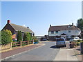
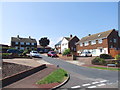
1
Stonecross Lea, Luton
This area was formerly a small estate of prefabs.
Image: © Chris Whippet
Taken: 20 Oct 2010
0.06 miles
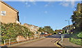
9
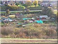
Allotments along Street End Road, Luton
Beside Golf driving range on righthand side.
Taken from footpath on Daisy Banks.
Image: © David Anstiss
Taken: 7 Nov 2008
0.15 miles