IMAGES TAKEN NEAR TO
Underdown Avenue, CHATHAM, ME4 5XR
Introduction
This page details the photographs taken nearby to Underdown Avenue, ME4 5XR by members of the Geograph project.
The Geograph project started in 2005 with the aim of publishing, organising and preserving representative images for every square kilometre of Great Britain, Ireland and the Isle of Man.

There are currently over 7.5m images from over14,400 individuals and you can help contribute to the project by visiting https://www.geograph.org.uk
Image Map (56 Images)


Getting Data...Please wait
Leaflet Map data © OpenStreetMap
Images are licensed for reuse under creativecommons.org/licenses/by-sa/2.0
Notes
- Clicking on the map will re-center to the selected point.
- The higher the marker number, the further away the image location is from the centre of the postcode.
Image Listing (56 Images Found)
Images are licensed for reuse under creativecommons.org/licenses/by-sa/2.0
Image
Details
Distance
4
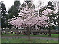
Flowering cherry tree in Palmerston Cemetery
In the background is Palmerston Road.
Image: © David Anstiss
Taken: 5 Apr 2012
0.07 miles
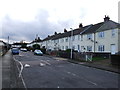
8
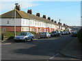
Haig Avenue, Chatham
Near Ansell Avenue.
Image: © Danny P Robinson
Taken: 24 Feb 2008
0.11 miles
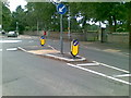
9
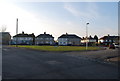
Open space at the junction of White Rd, Keyes Avenue & Haig Avenue, Chatham
Image: © N Chadwick
Taken: 31 Jan 2009
0.12 miles