IMAGES TAKEN NEAR TO
Magpie Hall Road, CHATHAM, ME4 5XH
Introduction
This page details the photographs taken nearby to Magpie Hall Road, ME4 5XH by members of the Geograph project.
The Geograph project started in 2005 with the aim of publishing, organising and preserving representative images for every square kilometre of Great Britain, Ireland and the Isle of Man.

There are currently over 7.5m images from over14,400 individuals and you can help contribute to the project by visiting https://www.geograph.org.uk
Image Map (Loading...)


Getting Data...Please wait
Leaflet Map data © OpenStreetMap
Images are licensed for reuse under creativecommons.org/licenses/by-sa/2.0
Notes
- Clicking on the map will re-center to the selected point.
- The higher the marker number, the further away the image location is from the centre of the postcode.
Image Listing (37 Images Found)
Images are licensed for reuse under creativecommons.org/licenses/by-sa/2.0
Image
Details
Distance


3
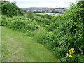
Viewpoint at Coney Banks, Chatham
This view looks across the Luton Valley from near Magpie Hall Road. The overgrown slope in the foreground is known as Coney Banks.
Image: © Marathon
Taken: 23 Jul 2011
0.09 miles
6

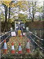
Memorial to the Holocaust in Palmerston Cemetery, Chatham
Chatham Cemetery is in two sections. This is the more easterly section and is also known as Chatham Cemetery, Palmerston Road. It seems to be newer than the western section. This moving memorial is close to the entrance in Kitchener Avenue at the Magpie Hall Road end. It was placed here by a daughter to her parents - her father being murdered in Auschwitz and her mother in Treblinka. Tellingly, no dates of death are shown.
Image: © Marathon
Taken: 23 Jul 2011
0.11 miles
7
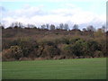
The Coney Banks from Barnfield Avenue, Chatham
The view is of the lower end of the Coney Banks.
Image: © Callum Burford
Taken: 7 Dec 2011
0.11 miles
8
Entrance Bridge to Fort Luton
Fort Luton, along Magpie Hall Road, was built in between 1876-1892, but was never armed. It was used by Army in war games in 1900s, including a trial siege in 1907. It was last used as a Model Museum in 1990s but now closed and now Very, Very Private. (Barbed wire, high fences and security cameras...)
Image: © David Anstiss
Taken: 7 Nov 2008
0.11 miles
9
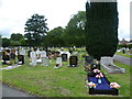
Palmerston Cemetery, Chatham
Chatham Cemetery is in two sections. This is the more easterly section and is also known as Chatham Cemetery, Palmerston Road. It seems to be newer than the western section.
Image: © Marathon
Taken: 23 Jul 2011
0.12 miles
10
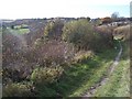
Coney Banks
Open land in Capstone/Luton Valley, with footpath.
Playing fields on left of photo are on Barnfield Road.
Houses on right of photo are on Magpie Hall Road.
Image: © David Anstiss
Taken: 7 Nov 2008
0.12 miles