IMAGES TAKEN NEAR TO
Skinner Street, CHATHAM, ME4 5RQ
Introduction
This page details the photographs taken nearby to Skinner Street, ME4 5RQ by members of the Geograph project.
The Geograph project started in 2005 with the aim of publishing, organising and preserving representative images for every square kilometre of Great Britain, Ireland and the Isle of Man.

There are currently over 7.5m images from over14,400 individuals and you can help contribute to the project by visiting https://www.geograph.org.uk
Image Map
Images are licensed for reuse under creativecommons.org/licenses/by-sa/2.0
Notes
- Clicking on the map will re-center to the selected point.
- The higher the marker number, the further away the image location is from the centre of the postcode.
Image Listing (192 Images Found)
Images are licensed for reuse under creativecommons.org/licenses/by-sa/2.0
Image
Details
Distance
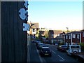
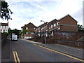
1
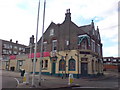
Sir Robert Peel Pub, Chatham
At Silver Hill and Skinner Street.
Image: © Danny P Robinson
Taken: 9 Aug 2008
0.01 miles
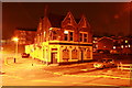
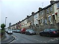
3
Sir Robert Peel Food & Wine Convenience Store, Skinner Street, Chatham
Disused pub put to use.
Image: © Richard Gadsby
Taken: 29 Mar 2012
0.02 miles
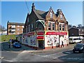
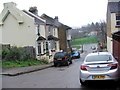
5
Mount Road/Silver Hill Junction
Outside No 20 Mount Road. Looking NNE towards Silver Hill. The Naval Memorial is in the distance.
Image: © Richard Gadsby
Taken: 31 Aug 2009
0.03 miles
8
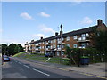
Coronation Flats, Jenkins Dale, Chatham
Image: © Chris Whippet
Taken: 2 Aug 2013
0.05 miles
10
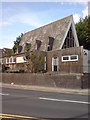
Enon Baptist Chapel, Chatham
On Claremont Way.
Image: © Danny P Robinson
Taken: 9 Aug 2008
0.05 miles