IMAGES TAKEN NEAR TO
Sturla Road, CHATHAM, ME4 5PA
Introduction
This page details the photographs taken nearby to Sturla Road, ME4 5PA by members of the Geograph project.
The Geograph project started in 2005 with the aim of publishing, organising and preserving representative images for every square kilometre of Great Britain, Ireland and the Isle of Man.

There are currently over 7.5m images from over14,400 individuals and you can help contribute to the project by visiting https://www.geograph.org.uk
Image Map
Images are licensed for reuse under creativecommons.org/licenses/by-sa/2.0
Notes
- Clicking on the map will re-center to the selected point.
- The higher the marker number, the further away the image location is from the centre of the postcode.
Image Listing (165 Images Found)
Images are licensed for reuse under creativecommons.org/licenses/by-sa/2.0
Image
Details
Distance
1
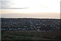
View of Chatham
Taken from the Great Lines.
Image: © N Chadwick
Taken: 26 Jan 2013
0.03 miles
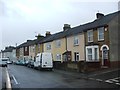
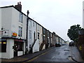
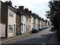
6
Mills Terrace, Chatham
This road leads from Otway Terrace to Magpie Hall Road.
Image: © David Anstiss
Taken: 26 Aug 2009
0.06 miles
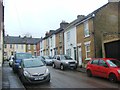
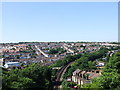
7
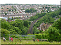
View south-west from above Gillingham railway tunnel, 2012
Image: © Robin Webster
Taken: 25 Jun 2012
0.06 miles
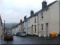
9
View over Chatham from the Great Lines
Image: © Chris Whippet
Taken: 1 Jun 2009
0.07 miles