IMAGES TAKEN NEAR TO
Castle Road, CHATHAM, ME4 5HX
Introduction
This page details the photographs taken nearby to Castle Road, ME4 5HX by members of the Geograph project.
The Geograph project started in 2005 with the aim of publishing, organising and preserving representative images for every square kilometre of Great Britain, Ireland and the Isle of Man.

There are currently over 7.5m images from over14,400 individuals and you can help contribute to the project by visiting https://www.geograph.org.uk
Image Map
Images are licensed for reuse under creativecommons.org/licenses/by-sa/2.0
Notes
- Clicking on the map will re-center to the selected point.
- The higher the marker number, the further away the image location is from the centre of the postcode.
Image Listing (104 Images Found)
Images are licensed for reuse under creativecommons.org/licenses/by-sa/2.0
Image
Details
Distance
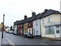
1
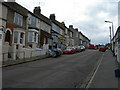
Dagmar Road, Chatham
Looking towards the junction of Clarence Road.
Image: © Danny P Robinson
Taken: 19 Mar 2008
0.01 miles
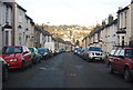
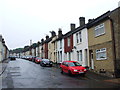
4
Gordon Road, Chatham
The terrain slopes steeply uphill in this part of Chatham and there is much 19th century terraced housing on these hillsides. This road is typical of the area.
Image: © Danny P Robinson
Taken: 23 Mar 2006
0.02 miles
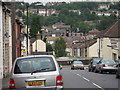
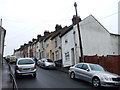
7

Leonard Road, Chatham
At the corner of Reform Road.
Image: © Danny P Robinson
Taken: 16 Mar 2008
0.06 miles

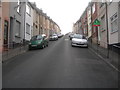
10
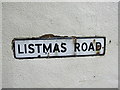
Vintage street nameplate, Listmas Road, Chatham
Image: © Chris Whippet
Taken: 26 May 2014
0.07 miles