IMAGES TAKEN NEAR TO
Luton Road, CHATHAM, ME4 5AE
Introduction
This page details the photographs taken nearby to Luton Road, ME4 5AE by members of the Geograph project.
The Geograph project started in 2005 with the aim of publishing, organising and preserving representative images for every square kilometre of Great Britain, Ireland and the Isle of Man.

There are currently over 7.5m images from over14,400 individuals and you can help contribute to the project by visiting https://www.geograph.org.uk
Image Map
Images are licensed for reuse under creativecommons.org/licenses/by-sa/2.0
Notes
- Clicking on the map will re-center to the selected point.
- The higher the marker number, the further away the image location is from the centre of the postcode.
Image Listing (180 Images Found)
Images are licensed for reuse under creativecommons.org/licenses/by-sa/2.0
Image
Details
Distance
3
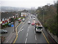
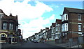
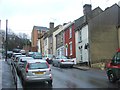
Chatham Hill (2)
Near the junction with Grange Hill, looking downhill towards Chatham. This is the A2, a major road through the Medway conurbation.
Image: © Danny P Robinson
Taken: 16 Mar 2008
0.04 miles
4
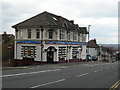
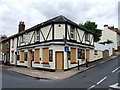
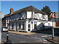
Domino's Pizza, Chatham Hill
On the corner of Whitehorse Hill. It looks like a converted pub.
Image: © Danny P Robinson
Taken: 19 Mar 2008
0.04 miles
8
Muslim Community Centre, Chatham
This was a former pub in Jan 2009 (see Image).
It then closed in June 2009 (see Image).
Was empty for awhile before it was converted.
Image: © David Anstiss
Taken: 14 Oct 2012
0.05 miles