IMAGES TAKEN NEAR TO
Walter Burke Way, Chatham Maritime, CHATHAM, ME4 4RQ
Introduction
This page details the photographs taken nearby to Walter Burke Way, Chatham Maritime, ME4 4RQ by members of the Geograph project.
The Geograph project started in 2005 with the aim of publishing, organising and preserving representative images for every square kilometre of Great Britain, Ireland and the Isle of Man.

There are currently over 7.5m images from over14,400 individuals and you can help contribute to the project by visiting https://www.geograph.org.uk
Image Map
Images are licensed for reuse under creativecommons.org/licenses/by-sa/2.0
Notes
- Clicking on the map will re-center to the selected point.
- The higher the marker number, the further away the image location is from the centre of the postcode.
Image Listing (251 Images Found)
Images are licensed for reuse under creativecommons.org/licenses/by-sa/2.0
Image
Details
Distance
1
Walter Burke Way, Chatham
This road leads from Dickens World and the Dockside Outlet shopping centre carparks towards Western Avenue.
The road is named after the Purser on HMS Bounty who held Lord Nelson when he died.
See http://en.wikipedia.org/wiki/Walter_Burke_(purser) for more details on the man.
Image: © David Anstiss
Taken: 10 Apr 2013
0.02 miles
3
Roundabout at entrance to the Historic Dockyard, Chatham
Main Gate Road goes straight into the attraction. Leviathan Way heads right towards Dickens World, a cinema and the Dockside Factory Outlet (large shopping complex) and Chatham Marina. Western Avenue heads left towards Maritime Way linking to the A289 Dual Carriageway. On the right is the Bell Mast Tower.
Image: © David Anstiss
Taken: 30 Oct 2009
0.04 miles
4
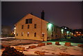
Medway Tunnel - Chatham Side
The Medway Tunnel was built in the mid 1990s. Just above the tunnel entrance is a car park for the Dockside Outlet Centre and some of the nearby attractions. The white tent-like building to the right is part of the Dockside Outlet Centre.
Image: © Danny P Robinson
Taken: 1 Sep 2007
0.05 miles
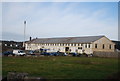
5
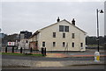
Lower Boat Store
Grade II* listed. http://www.britishlistedbuildings.co.uk/en-476593-lower-boat-store-chatham
Image: © N Chadwick
Taken: 10 Mar 2012
0.06 miles
6
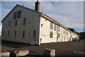
Lower Boat Store
Grade II* listed. http://www.britishlistedbuildings.co.uk/en-476593-lower-boat-store-
Image: © N Chadwick
Taken: 19 Jan 2013
0.06 miles
7
Lower Boat Store
Grade II* listed. http://www.britishlistedbuildings.co.uk/en-476593-lower-boat-store-chatham
Image: © N Chadwick
Taken: 10 Mar 2012
0.06 miles
8
Lower Boat Store
Grade II* listed. http://www.britishlistedbuildings.co.uk/en-476593-lower-boat-store-
Image: © N Chadwick
Taken: 25 Jan 2014
0.06 miles
9
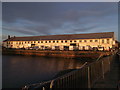
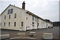
Lower Boat Store, Chatham Historic Docks
Grade II listed building within the Historic Dockyard Area.
Used for various purposes including a storage firm (hence the trucks).
As seen across the Mast Pond (another listed structure).
Image: © David Anstiss
Taken: 13 Dec 2011
0.06 miles
10
Lower Boat Store
Grade II* listed. http://www.britishlistedbuildings.co.uk/en-476593-lower-boat-store-
See alsoImage
Image: © N Chadwick
Taken: 25 Jan 2014
0.06 miles