IMAGES TAKEN NEAR TO
Church Street, CHATHAM, ME4 4BT
Introduction
This page details the photographs taken nearby to Church Street, ME4 4BT by members of the Geograph project.
The Geograph project started in 2005 with the aim of publishing, organising and preserving representative images for every square kilometre of Great Britain, Ireland and the Isle of Man.

There are currently over 7.5m images from over14,400 individuals and you can help contribute to the project by visiting https://www.geograph.org.uk
Image Map
Images are licensed for reuse under creativecommons.org/licenses/by-sa/2.0
Notes
- Clicking on the map will re-center to the selected point.
- The higher the marker number, the further away the image location is from the centre of the postcode.
Image Listing (328 Images Found)
Images are licensed for reuse under creativecommons.org/licenses/by-sa/2.0
Image
Details
Distance
1
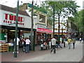
Cross Street, Chatham and Chatham Town Centre
Viewed from Market Hall car park.
Image: © Danny P Robinson
Taken: 2 Mar 2008
0.01 miles
2
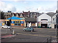
The Brook, Chatham
At the bottom of Slicketts Hill. Showing 2 car repair centres and a Chinese restaurant.
Image: © Danny P Robinson
Taken: 9 Aug 2008
0.01 miles
3
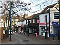
Chatham High Street
The eastern end, near Tesco and the White Lion pub.
Image: © Danny P Robinson
Taken: 17 Aug 2008
0.01 miles
4
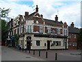
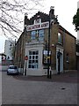
White Lion Pub, Chatham
On Chatham High Street, near The Brook and opposite Tesco. It could do with a bit of smartening up, I think. It looks very downmarket as a pub -- it might actually be a nice pub but you wouldn't want go in there to find out.
Image: © Danny P Robinson
Taken: 17 Aug 2008
0.01 miles
6
Whittaker Street/Church Street. Chatham
Salvation Army, at the junction of Church Street and Whittaker Street.
Image: © Richard Gadsby
Taken: 12 Jul 2009
0.01 miles
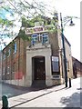
9
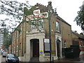
The Salvation Army Building, Chatham
Place of worship and meeting rooms. On the junction of Church Street (on the left) and Whittaker Street (on the right). Has stone plaque near roof which reads '1830'.
Image: © David Anstiss
Taken: 26 Aug 2009
0.02 miles
10
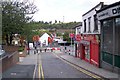
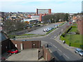
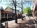
Church Street, Chatham
This short section of road leads from the New Road dual carriageway. Best Street then cuts Church Street in half. The other half of the street leads to the pedestrianised Chatham High Street.
Image: © David Anstiss
Taken: 10 Sep 2009
0.02 miles