IMAGES TAKEN NEAR TO
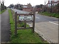
Edward Lake Drive, ME3 9UY
Introduction
This page details the photographs taken nearby to Edward Lake Drive, ME3 9UY by members of the Geograph project.
The Geograph project started in 2005 with the aim of publishing, organising and preserving representative images for every square kilometre of Great Britain, Ireland and the Isle of Man.

There are currently over 7.5m images from over14,400 individuals and you can help contribute to the project by visiting https://www.geograph.org.uk
Image Map (32 Images)


Leaflet Map data © OpenStreetMap
Images are licensed for reuse under creativecommons.org/licenses/by-sa/2.0
Notes
- Clicking on the map will re-center to the selected point.
- The higher the marker number, the further away the image location is from the centre of the postcode.
Image Listing (32 Images Found)
Images are licensed for reuse under creativecommons.org/licenses/by-sa/2.0
Image
Details
Distance
1
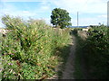
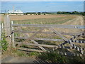
The Saxon Shore Way on its way to Hoo Flats
The Saxon Shore Way follows Kent's ancient coastline. In many places this is now miles inland. The Saxon Shore Way is named after the line of historic fortifications that defended the Kent coast at the end of the Roman era. It is 160 miles long and runs from Gravesend to Hastings.
Here it is heading away from the edge of Hoo St Werburgh towards the Medway Estuary at Hoo Flats and Rochester.
Image: © Marathon
Taken: 15 Aug 2013
0.13 miles
2
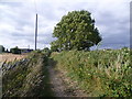
The Saxon Shore Way near Hoo St Werburgh
The Saxon Shore Way follows Kent's ancient coastline. In many places this is now miles inland. The Saxon Shore Way is named after the line of historic fortifications that defended the Kent coast at the end of the Roman era. It is 160 miles long and runs from Gravesend to Hastings.
Here it is heading from the Medway Estuary at Hoo Flats up to the edge of Hoo St Werburgh.
Image: © Marathon
Taken: 15 Aug 2013
0.14 miles
4
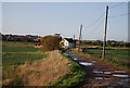
View from Stoke Road across the Medway Estuary
This is the view from Stoke Road on the edge of Hoo St Werburgh. It looks towards the Medway Estuary and Kingsnorth Power Station. Kingsnorth Power Station was built on the site of a former First World War airship base between 1963 and 1973. Kingsnorth Power Station ceased generation on 17th December 2012.
Image: © Marathon
Taken: 15 Aug 2013
0.15 miles
5
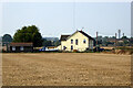
Abbots Court Cottages, Hoo St Werburgh
Image: © Robin Webster
Taken: 15 Sep 2016
0.15 miles
6
The Saxon Shore Way near Hoo St Werburgh
The Saxon Shore Way follows Kent's ancient coastline. In many places this is now miles inland. The Saxon Shore Way is named after the line of historic fortifications that defended the Kent coast at the end of the Roman era. It is 160 miles long and runs from Gravesend to Hastings.
Here it is heading away from the edge of Hoo St Werburgh towards the Medway Estuary at Hoo Flats and Rochester.
Image: © Marathon
Taken: 15 Aug 2013
0.16 miles
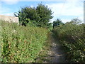
8
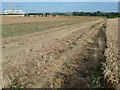
Footpath leading away from Stoke Road
This is the view from Stoke Road on the edge of Hoo St Werburgh. A footpath follows the edge of the cornfield straight ahead and meets the Saxon Shore Way at the treeline. The view looks towards the Medway Estuary and Kingsnorth Power Station. Kingsnorth Power Station was built on the site of a former First World War airship base between 1963 and 1973. Kingsnorth Power Station ceased generation on 17th December 2012.
Image: © Marathon
Taken: 15 Aug 2013
0.17 miles
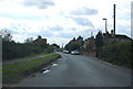
9

Drainage ditch between two fields near the Hoo transmitter
Image: © N Chadwick
Taken: 15 Nov 2009
0.18 miles