IMAGES TAKEN NEAR TO
Vicarage Lane, ROCHESTER, ME3 9TW
Introduction
This page details the photographs taken nearby to Vicarage Lane, ME3 9TW by members of the Geograph project.
The Geograph project started in 2005 with the aim of publishing, organising and preserving representative images for every square kilometre of Great Britain, Ireland and the Isle of Man.

There are currently over 7.5m images from over14,400 individuals and you can help contribute to the project by visiting https://www.geograph.org.uk
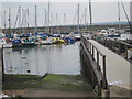
Image Map
Images are licensed for reuse under creativecommons.org/licenses/by-sa/2.0
Notes
- Clicking on the map will re-center to the selected point.
- The higher the marker number, the further away the image location is from the centre of the postcode.
Image Listing (75 Images Found)
Images are licensed for reuse under creativecommons.org/licenses/by-sa/2.0
Image
Details
Distance
2
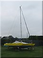
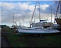
Sunny Trimaran
In Hoo Ness Yacht Club, on not a nice sunny day!
Image: © David Anstiss
Taken: 29 Jul 2011
0.02 miles
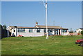
6
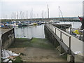
Slipway and pier in Hoo Ness Yacht Club
Looking towards the marina on the River Medway.
Image: © David Anstiss
Taken: 29 Jul 2011
0.04 miles
7
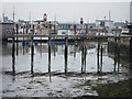
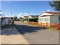
Jetty at Port Werburgh
Fixed house boats at Port Werburgh.
Image: © Oast House Archive
Taken: 29 Jul 2011
0.04 miles