IMAGES TAKEN NEAR TO
The Copse, Vicarage Lane, ROCHESTER, ME3 9TP
Introduction
This page details the photographs taken nearby to The Copse, Vicarage Lane, ME3 9TP by members of the Geograph project.
The Geograph project started in 2005 with the aim of publishing, organising and preserving representative images for every square kilometre of Great Britain, Ireland and the Isle of Man.

There are currently over 7.5m images from over14,400 individuals and you can help contribute to the project by visiting https://www.geograph.org.uk
Image Map
Images are licensed for reuse under creativecommons.org/licenses/by-sa/2.0
Notes
- Clicking on the map will re-center to the selected point.
- The higher the marker number, the further away the image location is from the centre of the postcode.
Image Listing (89 Images Found)
Images are licensed for reuse under creativecommons.org/licenses/by-sa/2.0
Image
Details
Distance
3
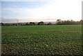
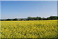
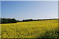
View south from the Saxon Shore Way, Hoo St Werburgh
Image: © N Chadwick
Taken: 15 Nov 2009
0.11 miles
5
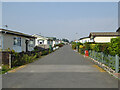
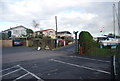
Marine Drive, Port Werburgh
Port Werburgh appears to be the new name for Hoo Marina Park. The park is a large settlement of chalets.
Image: © Robin Webster
Taken: 15 Sep 2016
0.13 miles
6
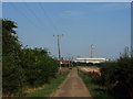
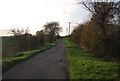
Lane leading from Cockham Farm towards Vicarage Lane, Hoo St. Werburgh
Image: © Chris Whippet
Taken: 5 Sep 2013
0.15 miles
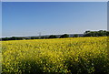
8
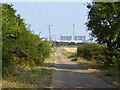
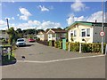
Restricted byway to Vicarage Lane, Hoo
A well-surfaced lane from Cockham Farm. It is used by the inland version of the Saxon Shore Way.
Image: © Robin Webster
Taken: 15 Sep 2016
0.16 miles