IMAGES TAKEN NEAR TO
Grebe Close, ROCHESTER, ME3 9SX
Introduction
This page details the photographs taken nearby to Grebe Close, ME3 9SX by members of the Geograph project.
The Geograph project started in 2005 with the aim of publishing, organising and preserving representative images for every square kilometre of Great Britain, Ireland and the Isle of Man.

There are currently over 7.5m images from over14,400 individuals and you can help contribute to the project by visiting https://www.geograph.org.uk
Image Map
Images are licensed for reuse under creativecommons.org/licenses/by-sa/2.0
Notes
- Clicking on the map will re-center to the selected point.
- The higher the marker number, the further away the image location is from the centre of the postcode.
Image Listing (100 Images Found)
Images are licensed for reuse under creativecommons.org/licenses/by-sa/2.0
Image
Details
Distance
7
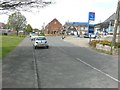
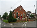
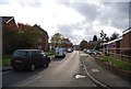
Looking northwest along Cuckolds Green Road, Lower Stoke
Towards the Bible Christian chapel, with a date-stone of 1889, that is situated on the corner of Allhallows Road.
Image: © John Baker
Taken: 5 Apr 2014
0.03 miles
8
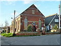
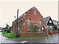
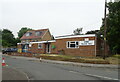
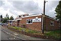
Methodist Chapel, Lower Stoke
Built in 1889 as a Bible Christian Chapel.
Image: © Robin Webster
Taken: 7 Feb 2014
0.03 miles