IMAGES TAKEN NEAR TO
Button Drive, ROCHESTER, ME3 9SR
Introduction
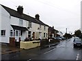
This page details the photographs taken nearby to Button Drive, ME3 9SR by members of the Geograph project.
The Geograph project started in 2005 with the aim of publishing, organising and preserving representative images for every square kilometre of Great Britain, Ireland and the Isle of Man.

There are currently over 7.5m images from over14,400 individuals and you can help contribute to the project by visiting https://www.geograph.org.uk
Image Map
Images are licensed for reuse under creativecommons.org/licenses/by-sa/2.0
Notes
- Clicking on the map will re-center to the selected point.
- The higher the marker number, the further away the image location is from the centre of the postcode.
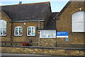
Image Listing (77 Images Found)
Images are licensed for reuse under creativecommons.org/licenses/by-sa/2.0
Image
Details
Distance
2
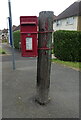
Elizabeth II postbox on Allhallows Road, Lower Stoke
Postbox No. ME3 241.
Image: © JThomas
Taken: 23 Jun 2022
0.04 miles
5

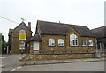
Stoke Community School
This is Stoke Community School in Lower Stoke Kent. The picture was taken from the recreation ground.
Image: © Glyn Baker
Taken: 28 Oct 2006
0.07 miles