IMAGES TAKEN NEAR TO
Creek Lane, ROCHESTER, ME3 9SE
Introduction
This page details the photographs taken nearby to Creek Lane, ME3 9SE by members of the Geograph project.
The Geograph project started in 2005 with the aim of publishing, organising and preserving representative images for every square kilometre of Great Britain, Ireland and the Isle of Man.

There are currently over 7.5m images from over14,400 individuals and you can help contribute to the project by visiting https://www.geograph.org.uk
Image Map
Images are licensed for reuse under creativecommons.org/licenses/by-sa/2.0
Notes
- Clicking on the map will re-center to the selected point.
- The higher the marker number, the further away the image location is from the centre of the postcode.
Image Listing (71 Images Found)
Images are licensed for reuse under creativecommons.org/licenses/by-sa/2.0
Image
Details
Distance
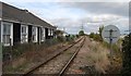
2
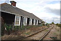
Stoke Crossing Cottage
By the Hundred Hoo line.
Image: © N Chadwick
Taken: 29 Oct 2011
0.01 miles
4
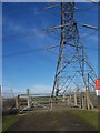
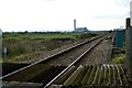
Level Crossing and Pylon
On track near Sea Wall on River Medway. Mineral Railway heads right to Grain from Hoo Junction. Track leads north to Stoke Road.
Image: © David Anstiss
Taken: 9 Jan 2009
0.02 miles
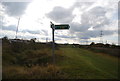
5
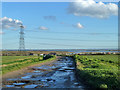
Creek Lane
Leading down to Stoke Creek, but publicly only a footpath.
Image: © Robin Webster
Taken: 7 Feb 2014
0.02 miles
6
Kingsnorth Power Station from Stoke Creek Crossing Upper Stoke
Image: © Peter Skynner
Taken: 13 Dec 2014
0.02 miles
7
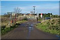
Creek Lane Upper Stoke Railway Crossing
Image: © Peter Skynner
Taken: 13 Dec 2014
0.02 miles
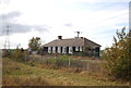
10
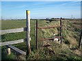
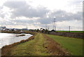
Stile on Sea Wall
Footpath along River Medway Sea wall, near Stoke Saltings leads to Stoke Wharf.
Image: © David Anstiss
Taken: 9 Jan 2009
0.02 miles