IMAGES TAKEN NEAR TO
St. Georges Walk, ROCHESTER, ME3 9PP
Introduction
This page details the photographs taken nearby to St. Georges Walk, ME3 9PP by members of the Geograph project.
The Geograph project started in 2005 with the aim of publishing, organising and preserving representative images for every square kilometre of Great Britain, Ireland and the Isle of Man.

There are currently over 7.5m images from over14,400 individuals and you can help contribute to the project by visiting https://www.geograph.org.uk
Image Map
Images are licensed for reuse under creativecommons.org/licenses/by-sa/2.0
Notes
- Clicking on the map will re-center to the selected point.
- The higher the marker number, the further away the image location is from the centre of the postcode.
Image Listing (46 Images Found)
Images are licensed for reuse under creativecommons.org/licenses/by-sa/2.0
Image
Details
Distance
3
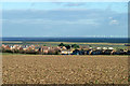
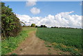
View east across Allhallows
Looking towards the mouth of the Thames estuary with a distant wind farm, and much less distinct, two groups of Maunsell forts.
Image: © Robin Webster
Taken: 7 Feb 2014
0.06 miles