IMAGES TAKEN NEAR TO
New Hall Farm Lane, ROCHESTER, ME3 9PB
Introduction
This page details the photographs taken nearby to New Hall Farm Lane, ME3 9PB by members of the Geograph project.
The Geograph project started in 2005 with the aim of publishing, organising and preserving representative images for every square kilometre of Great Britain, Ireland and the Isle of Man.

There are currently over 7.5m images from over14,400 individuals and you can help contribute to the project by visiting https://www.geograph.org.uk
Image Map
Images are licensed for reuse under creativecommons.org/licenses/by-sa/2.0
Notes
- Clicking on the map will re-center to the selected point.
- The higher the marker number, the further away the image location is from the centre of the postcode.
Image Listing (5 Images Found)
Images are licensed for reuse under creativecommons.org/licenses/by-sa/2.0
Image
Details
Distance
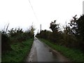
1
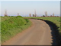
View towards Newhall Farm
Looking from the junction between Cuckolds Lane and New Hall Farm Lane.
Image: © Robin Webster
Taken: 7 Feb 2014
0.05 miles
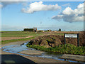
2
Newhall Farm, Allhallows
Seen from New Hall Farm Lane. Water Tower on Ratcliffe Highway Image seen in background, in middle of photo.
Image: © David Anstiss
Taken: 9 Jan 2009
0.06 miles
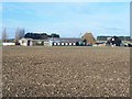
3
New Hall Farm Lane, near Allhallows
A view westwards on New Hall Farm Lane, on the Hoo peninsula.
Image: © Malc McDonald
Taken: 23 Feb 2019
0.15 miles
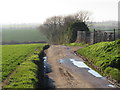
4
New Hall Farm Lane, near Allhallows
New Hall Farm Lane is a minor road on the Hoo peninsula in Kent.
Image: © Malc McDonald
Taken: 23 Feb 2019
0.21 miles