IMAGES TAKEN NEAR TO
Jacobs Lane, ROCHESTER, ME3 9NJ
Introduction
This page details the photographs taken nearby to Jacobs Lane, ME3 9NJ by members of the Geograph project.
The Geograph project started in 2005 with the aim of publishing, organising and preserving representative images for every square kilometre of Great Britain, Ireland and the Isle of Man.

There are currently over 7.5m images from over14,400 individuals and you can help contribute to the project by visiting https://www.geograph.org.uk
Image Map
Images are licensed for reuse under creativecommons.org/licenses/by-sa/2.0
Notes
- Clicking on the map will re-center to the selected point.
- The higher the marker number, the further away the image location is from the centre of the postcode.
Image Listing (29 Images Found)
Images are licensed for reuse under creativecommons.org/licenses/by-sa/2.0
Image
Details
Distance
1
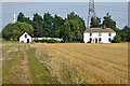
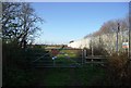
Burnt House Farm
Kennels and cattery to the left of the house.
Image: © Robin Webster
Taken: 15 Sep 2016
0.01 miles
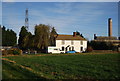
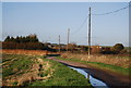
5
Footpath towards Burnt House Farm
The fence of Kingsnorth Power Station on the right.
Image: © Robin Webster
Taken: 15 Sep 2016
0.09 miles
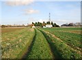
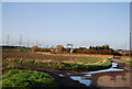
7
Muddy field near Kingsnorth Power Station
Image: © N Chadwick
Taken: 15 Nov 2009
0.11 miles
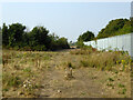
8
Stile on the path by the side of Kingsnorth Power Station
Image: © N Chadwick
Taken: 15 Nov 2009
0.11 miles
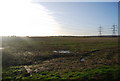
9
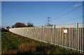
Boundary fence, Kingsnorth Power Station
Image: © N Chadwick
Taken: 15 Nov 2009
0.13 miles