IMAGES TAKEN NEAR TO
Abbotts Court Road, ROCHESTER, ME3 9LJ
Introduction
This page details the photographs taken nearby to Abbotts Court Road, ME3 9LJ by members of the Geograph project.
The Geograph project started in 2005 with the aim of publishing, organising and preserving representative images for every square kilometre of Great Britain, Ireland and the Isle of Man.

There are currently over 7.5m images from over14,400 individuals and you can help contribute to the project by visiting https://www.geograph.org.uk
Image Map
Images are licensed for reuse under creativecommons.org/licenses/by-sa/2.0
Notes
- Clicking on the map will re-center to the selected point.
- The higher the marker number, the further away the image location is from the centre of the postcode.
Image Listing (163 Images Found)
Images are licensed for reuse under creativecommons.org/licenses/by-sa/2.0
Image
Details
Distance
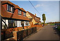


4

Abbott's Court Rd (Saxon Shore Way), Hoo St Werburgh
Image: © N Chadwick
Taken: 15 Nov 2009
0.03 miles
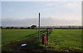
5
Footpath junction, Hoo St Werburgh
Two branches of the Saxon Shore Way merge.
Image: © N Chadwick
Taken: 23 May 2010
0.03 miles


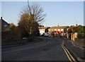
8
Saxon Shore Way link path, Hoo St Werburgh
This path links two parts of the SSW, the riverside route & the inland route.
Image: © N Chadwick
Taken: 15 Nov 2009
0.04 miles
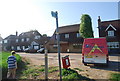
10

'The Chequers' at Hoo
Quite a tall, narrow building, with a gambrel roof. A Shepherd Neame house.
Image: © Stefan Czapski
Taken: 28 May 2016
0.05 miles