IMAGES TAKEN NEAR TO
Stoke Road, ROCHESTER, ME3 9BE
Introduction
This page details the photographs taken nearby to Stoke Road, ME3 9BE by members of the Geograph project.
The Geograph project started in 2005 with the aim of publishing, organising and preserving representative images for every square kilometre of Great Britain, Ireland and the Isle of Man.

There are currently over 7.5m images from over14,400 individuals and you can help contribute to the project by visiting https://www.geograph.org.uk
Image Map
Images are licensed for reuse under creativecommons.org/licenses/by-sa/2.0
Notes
- Clicking on the map will re-center to the selected point.
- The higher the marker number, the further away the image location is from the centre of the postcode.
Image Listing (110 Images Found)
Images are licensed for reuse under creativecommons.org/licenses/by-sa/2.0
Image
Details
Distance


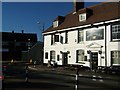
5
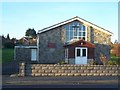
Holy Family Catholic Church, Hoo St.Werburgh
On Stone Road. In the parish of the English Martyrs, Strood.
Image: © David Anstiss
Taken: 7 Dec 2008
0.04 miles
7
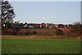
Looking across the fields to Hoo St Werburgh
Image: © N Chadwick
Taken: 15 Nov 2009
0.07 miles
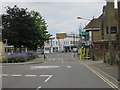
10
Five Bells Pub, Hoo St. Werburgh
On junction of Stone Road and Bells Lane.
Image: © David Anstiss
Taken: 7 Dec 2008
0.08 miles