IMAGES TAKEN NEAR TO
Main Road, ROCHESTER, ME3 9AD
Introduction
This page details the photographs taken nearby to Main Road, ME3 9AD by members of the Geograph project.
The Geograph project started in 2005 with the aim of publishing, organising and preserving representative images for every square kilometre of Great Britain, Ireland and the Isle of Man.

There are currently over 7.5m images from over14,400 individuals and you can help contribute to the project by visiting https://www.geograph.org.uk
Image Map
Images are licensed for reuse under creativecommons.org/licenses/by-sa/2.0
Notes
- Clicking on the map will re-center to the selected point.
- The higher the marker number, the further away the image location is from the centre of the postcode.
Image Listing (158 Images Found)
Images are licensed for reuse under creativecommons.org/licenses/by-sa/2.0
Image
Details
Distance
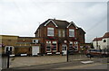
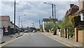
4
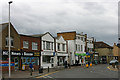
Shops in Main Road, Hoo St Werburgh
These shops stand at the crossroads in the centre of the village.
Image: © David Kemp
Taken: 7 Apr 2012
0.02 miles
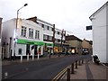
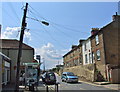
9

Hoo St Werburgh
This road, passing through the centre of Hoo St Werburgh, is on the route of National Cycle Network route 179 "The Heron Trail". The route was previously designated as regional cycle route 18.
Image: © Malc McDonald
Taken: 23 Feb 2019
0.03 miles