IMAGES TAKEN NEAR TO
Main Road, ROCHESTER, ME3 9AB
Introduction
This page details the photographs taken nearby to Main Road, ME3 9AB by members of the Geograph project.
The Geograph project started in 2005 with the aim of publishing, organising and preserving representative images for every square kilometre of Great Britain, Ireland and the Isle of Man.

There are currently over 7.5m images from over14,400 individuals and you can help contribute to the project by visiting https://www.geograph.org.uk
Image Map
Images are licensed for reuse under creativecommons.org/licenses/by-sa/2.0
Notes
- Clicking on the map will re-center to the selected point.
- The higher the marker number, the further away the image location is from the centre of the postcode.
Image Listing (93 Images Found)
Images are licensed for reuse under creativecommons.org/licenses/by-sa/2.0
Image
Details
Distance
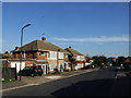
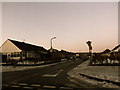
2

Mercian Road, Hoo St Werburgh
Mercian Road is a small housing development in Hoo St Werburgh, in Kent.
Image: © Malc McDonald
Taken: 23 Feb 2019
0.03 miles

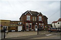
5
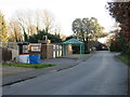
The Elms medical practice, Hoo St Werburgh
The Elms medical practice in the Kent village of Hoo St Werburgh.
Image: © Malc McDonald
Taken: 23 Feb 2019
0.08 miles
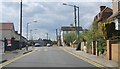
6
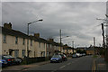
Terraced housing in Main Road, Hoo St Werburgh
Image: © David Kemp
Taken: 7 Apr 2012
0.08 miles
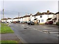
7
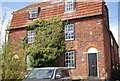
Meadow House
Grade II listed. http://www.britishlistedbuildings.co.uk/en-172905-meadow-house-hoo-st-werburgh
Image: © N Chadwick
Taken: 21 Apr 2012
0.09 miles