IMAGES TAKEN NEAR TO
Wybournes Lane, ROCHESTER, ME3 8SB
Introduction
This page details the photographs taken nearby to Wybournes Lane, ME3 8SB by members of the Geograph project.
The Geograph project started in 2005 with the aim of publishing, organising and preserving representative images for every square kilometre of Great Britain, Ireland and the Isle of Man.

There are currently over 7.5m images from over14,400 individuals and you can help contribute to the project by visiting https://www.geograph.org.uk
Image Map
Images are licensed for reuse under creativecommons.org/licenses/by-sa/2.0
Notes
- Clicking on the map will re-center to the selected point.
- The higher the marker number, the further away the image location is from the centre of the postcode.
Image Listing (65 Images Found)
Images are licensed for reuse under creativecommons.org/licenses/by-sa/2.0
Image
Details
Distance
2
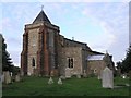
St. Margaret's Church, High Halstow
Built on the highest point of the Hoo peninsula, this church was mentioned in the 1086 Domesday Book.
Image: © Hywel Williams
Taken: 27 Aug 2005
0.04 miles
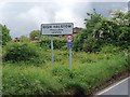
8
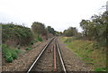
View down the line from Wybourne Crossing
Situated on Wybournes Lane, a quiet no through road leading only to Wybournes Farm, this level crossing sees very few trains. Passenger trains ran on this line from 1882 to 1961, which seems surprising now as it doesn't really serve any significant centres of population. It is still in use by regular container trains on their way via Hoo Junction to and from Thamesport on the Isle of Grain.
This is the view towards Thamesport. A footpath crosses the line just ahead.
Between here and the foot crossing was the site of High Halstow Halt. This was opened by the South Eastern & Chatham Railway in July 1906 and closed on 4th December 1961 - the day that all passenger services ceased on the line. For more information on High Halstow Halt see http://www.disused-stations.org.uk/h/high_halstow_halt/index.shtml
Image: © Marathon
Taken: 13 Aug 2013
0.12 miles
10
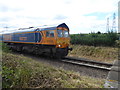
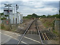
A freight train approaches Wybourne Crossing
This aggregate train is on its way from Grain to Brentford. It is the same train as seen at https://www.geograph.org.uk/photo/5815512 For more about Wybourne Crossing and High Halstow Halt see https://www.geograph.org.uk/photo/5822447
Image: © Marathon
Taken: 18 Jun 2018
0.12 miles