IMAGES TAKEN NEAR TO
Moat Farm Road, ROCHESTER, ME3 8RG
Introduction
This page details the photographs taken nearby to Moat Farm Road, ME3 8RG by members of the Geograph project.
The Geograph project started in 2005 with the aim of publishing, organising and preserving representative images for every square kilometre of Great Britain, Ireland and the Isle of Man.

There are currently over 7.5m images from over14,400 individuals and you can help contribute to the project by visiting https://www.geograph.org.uk
Image Map
Images are licensed for reuse under creativecommons.org/licenses/by-sa/2.0
Notes
- Clicking on the map will re-center to the selected point.
- The higher the marker number, the further away the image location is from the centre of the postcode.
Image Listing (27 Images Found)
Images are licensed for reuse under creativecommons.org/licenses/by-sa/2.0
Image
Details
Distance
3
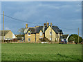
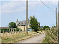
House, Moat Farm
This substantial house was built in late Victorian times, with apparently a later extension at the near end. The farm was called Spongs's Farm before that, the house apparently being further east where there is still a cottage.
Image: © Robin Webster
Taken: 7 Feb 2014
0.09 miles
4
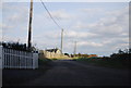
Moat Farm Road, St. Mary Hoo
The road leading from the old church to Moat Farm.
Image: © Chris Whippet
Taken: 16 Jul 2009
0.16 miles
5
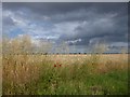
Cornfield at St Mary Hoo
This view is from Hall Road as it enters the village of St Mary Hoo.
Image: © Marathon
Taken: 14 Jul 2019
0.17 miles
6
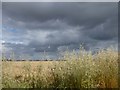
Stormy sky at St Mary Hoo
This view is from Hall Road as it enters the village of St Mary Hoo.
Image: © Marathon
Taken: 14 Jul 2019
0.19 miles
8
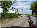
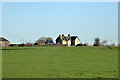
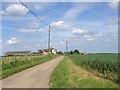
Hall Road, St Mary Hoo
The small village of St Mary Hoo is one of the most attractive on the Hoo Peninsula. It is situated on a no through road leading off Ratcliffe Highway. This is Hall Road as the road bends to the right by the pond. Straight ahead is Moat Farm Road with Moat Farm in the distance.
Image: © Marathon
Taken: 15 Aug 2013
0.22 miles
9
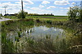
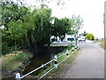
Pond by Coombe Farm Lane
An attractive small pond by the roadside south of Coombe House.
Image: © Trevor Harris
Taken: 7 May 2021
0.22 miles