IMAGES TAKEN NEAR TO
St. Mary Hoo, ROCHESTER, ME3 8FA
Introduction
This page details the photographs taken nearby to ME3 8FA by members of the Geograph project.
The Geograph project started in 2005 with the aim of publishing, organising and preserving representative images for every square kilometre of Great Britain, Ireland and the Isle of Man.

There are currently over 7.5m images from over14,400 individuals and you can help contribute to the project by visiting https://www.geograph.org.uk
Image Map
Images are licensed for reuse under creativecommons.org/licenses/by-sa/2.0
Notes
- Clicking on the map will re-center to the selected point.
- The higher the marker number, the further away the image location is from the centre of the postcode.
Image Listing (99 Images Found)
Images are licensed for reuse under creativecommons.org/licenses/by-sa/2.0
Image
Details
Distance
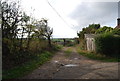
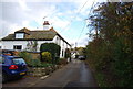
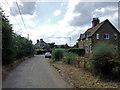
3
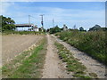
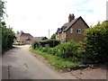
Track to St Mary Hoo
This track leads from the Saxon Shore Way near High Halstow, across Decoy Hill Road and past Newlands Farm to St Mary Hoo. Ross Farm is to the left and the tower of St Mary's Church is just ahead - see http://www.geograph.org.uk/photo/3603077
Image: © Marathon
Taken: 13 Sep 2014
0.01 miles
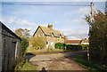
4
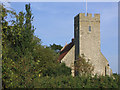
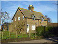
St Mary Hoo
This church, which has given its name to a village on the Hoo peninsula, is now a private house: http://en.wikipedia.org/wiki/St_Mary_Hoo.
Image: © Peter Wyatt
Taken: 9 Sep 2006
0.03 miles