IMAGES TAKEN NEAR TO
Town Road, ROCHESTER, ME3 8EP
Introduction
This page details the photographs taken nearby to Town Road, ME3 8EP by members of the Geograph project.
The Geograph project started in 2005 with the aim of publishing, organising and preserving representative images for every square kilometre of Great Britain, Ireland and the Isle of Man.

There are currently over 7.5m images from over14,400 individuals and you can help contribute to the project by visiting https://www.geograph.org.uk
Image Map
Images are licensed for reuse under creativecommons.org/licenses/by-sa/2.0
Notes
- Clicking on the map will re-center to the selected point.
- The higher the marker number, the further away the image location is from the centre of the postcode.
Image Listing (15 Images Found)
Images are licensed for reuse under creativecommons.org/licenses/by-sa/2.0
Image
Details
Distance
1
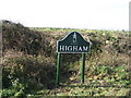
One of the new Higham village signs
Higham Parish Council have recently sponsored and provided new village boundary signs. They all depict different characters from the novels of Charles Dickens who lived in the village. For more information on Higham parish, please click here...http://www.higham-kent-pc.gov.uk/
Image: © Clive Stanley
Taken: 15 Feb 2007
0.04 miles
2
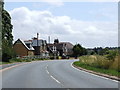
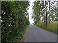
B2000 Lower Rochester Road, heading towards Wainscott
Image: © Chris Whippet
Taken: 15 Jul 2009
0.18 miles
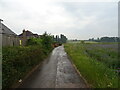
4
Rudge Cottage, Lower Rochester Road, near Higham
Image: © Chris Whippet
Taken: 15 Jul 2009
0.21 miles
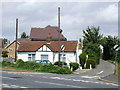
7
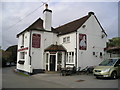
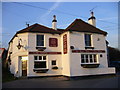
The Stone Horse Pub, Rochester
Dillywood Lane, Rochester, ME3 8EN near to the line of The Strood Canal Tunnels
Image: © canalandriversidepubs co uk
Taken: 5 Feb 2010
0.23 miles
9
The Stone Horse
in Dillywood Lane at the junction with Stonehorse Lane. Confusingly, the map marks a Stone House Farm near here.
The local morris side came here in June 2006 http://www.flickr.com/photos/83753075%40N00/sets/72157594182546786/
Image: © Roger W Haworth
Taken: 7 Feb 2007
0.23 miles
10
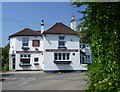
The Stone Horse pub, Dillywood Lane
The Stone Horse pub in Dillywood Lane is seen here from Stonehorse Lane.
Image: © Marathon
Taken: 6 Jun 2013
0.23 miles