IMAGES TAKEN NEAR TO
Ropers Green Lane, ROCHESTER, ME3 8AD
Introduction
This page details the photographs taken nearby to Ropers Green Lane, ME3 8AD by members of the Geograph project.
The Geograph project started in 2005 with the aim of publishing, organising and preserving representative images for every square kilometre of Great Britain, Ireland and the Isle of Man.

There are currently over 7.5m images from over14,400 individuals and you can help contribute to the project by visiting https://www.geograph.org.uk
Image Map
Images are licensed for reuse under creativecommons.org/licenses/by-sa/2.0
Notes
- Clicking on the map will re-center to the selected point.
- The higher the marker number, the further away the image location is from the centre of the postcode.
Image Listing (15 Images Found)
Images are licensed for reuse under creativecommons.org/licenses/by-sa/2.0
Image
Details
Distance
1
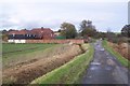
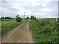
Roper's Farm on Roper's Green Lane
This byway leads from Roper's Lane towards Parbrook Road, near Fenn Street.
The byway is also used by the Saxon Shore Way (long distance path) heading to High Halstow from Hoo.
Image: © David Anstiss
Taken: 1 Nov 2009
0.01 miles
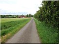
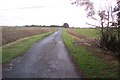
2
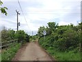
Roper's Green Lane, near High Halstow
Image: © Chris Whippet
Taken: 20 May 2016
0.04 miles
3
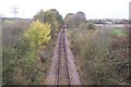
Mineral Railway towards Hoo Junction
This single track railway heads from Grain towards Hoo Junction near Gravesend.
Seen from a byway bridge near Roper's Farm. Sharnal Street is seen in the background on the right.
Image: © David Anstiss
Taken: 1 Nov 2009
0.07 miles
4
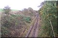
The Mineral Railway to Grain
Single track freight line heading to Grain from Hoo Junction.
Seen from a byway bridge over the railway near Roper's Farm.
Image: © David Anstiss
Taken: 1 Nov 2009
0.07 miles
5
Roper's Green Lane, near High Halstow
Image: © Chris Whippet
Taken: 20 May 2016
0.08 miles
6
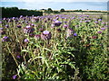
Globe artichoke in field next to Roper's Green Lane
This field of globe artichoke next to Roper's Green Lane is very colourful - see https://www.google.co.uk/search?q=artichoke&source=lnms&tbm=isch&sa=X&ei=94IQUs1Mo7LRBaqggZAC&ved=0CAkQ_AUoAQ&biw=1024&bih=511
Roper's Green Lane is shown as a byway on the map and is also followed by the Saxon Shore Way. The lane is beyond the hedge on the left.
The Saxon Shore Way follows Kent's ancient coastline. In many places this is now miles inland. The Saxon Shore Way is named after the line of historic fortifications that defended the Kent coast at the end of the Roman era. It is 160 miles long and runs from Gravesend to Hastings.
Image: © Marathon
Taken: 15 Aug 2013
0.12 miles
7
Roper's Green Lane, near High Halstow
Image: © Chris Whippet
Taken: 20 May 2016
0.12 miles
8
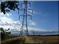
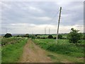
Pylons seen from Roper's Green Lane
Although pylons can and often are a blot on the landscape there is no doubt that they can be dramatic in otherwise flat and featureless areas. This is the view from Roper's Green Lane which is shown as a byway on the map and is also followed by the Saxon Shore Way.
The Saxon Shore Way follows Kent's ancient coastline. In many places this is now miles inland. The Saxon Shore Way is named after the line of historic fortifications that defended the Kent coast at the end of the Roman era. It is 160 miles long and runs from Gravesend to Hastings. Here it has just left Hoo St Werburgh on its way to Gravesend.
Image: © Marathon
Taken: 15 Aug 2013
0.12 miles
9
Roper's Green Lane, near High Halstow
Image: © Chris Whippet
Taken: 20 May 2016
0.16 miles
10
Roper's Green Lane towards Hoo
This byway leads from Fenn Street past Roper's Farm towards Roper's Lane. It is also used by the Saxon Shore Way (long distance path).
Image: © David Anstiss
Taken: 1 Nov 2009
0.17 miles