IMAGES TAKEN NEAR TO
Gravesend Road, ROCHESTER, ME3 7NZ
Introduction
This page details the photographs taken nearby to Gravesend Road, ME3 7NZ by members of the Geograph project.
The Geograph project started in 2005 with the aim of publishing, organising and preserving representative images for every square kilometre of Great Britain, Ireland and the Isle of Man.

There are currently over 7.5m images from over14,400 individuals and you can help contribute to the project by visiting https://www.geograph.org.uk
Image Map
Images are licensed for reuse under creativecommons.org/licenses/by-sa/2.0
Notes
- Clicking on the map will re-center to the selected point.
- The higher the marker number, the further away the image location is from the centre of the postcode.
Image Listing (45 Images Found)
Images are licensed for reuse under creativecommons.org/licenses/by-sa/2.0
Image
Details
Distance
1
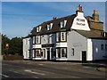
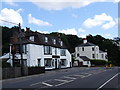
Sir John Falstaff Public House, Higham
On junction of Gravesend Road and Telegraph Hill.
Image: © David Anstiss
Taken: 20 Nov 2008
0.00 miles
2
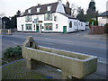
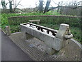
Higham horse trough
in Gravesend Road opposite the end of Telegraph Hill. A plate on the ground (just visible in this photo) says that the trough was "restored in 1996 by IMPACT, Gravesham Borough Council, with contributions from Dickens Country Protection Society and Higham Parish Council".
The pub behind is called the Sir John Falstaff.
Image: © Roger W Haworth
Taken: 7 Feb 2007
0.00 miles
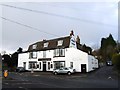
3
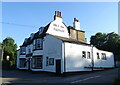
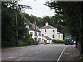
The Sir John Falstaff, Higham
On Gravesend Road.
See Image] for sign.
Image: © JThomas
Taken: 22 Jun 2022
0.01 miles
5
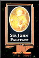
Sign for the Sir John Falstaff, Higham
See Image] for context.
Image: © JThomas
Taken: 22 Jun 2022
0.01 miles
9
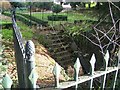
Subway to Gad's Hill Place
Goes under busy A226 Gravesend Road. Now in a private garden on Forge Lane.
Other part of subway may be in Gad's Hill Place garden, which is now Gad's Hill School. Unable to see due to high wall along Gravesend Road.
Image: © David Anstiss
Taken: 20 Nov 2008
0.03 miles
10
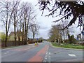
The Old Dover Road - now the A226 - at Gadshill
Looking at this road these days it is hard to imagine that until about 40 years ago it was the main road linking London to the Continent - and had been so for centuries. It seems a shame that it is now known simply as Gravesend Road - centuries of history stand to be forgotten. It was as the Dover Road that it was known to both Shakespeare and Dickens Image - whoever looks after tourism in this part of Kent seems to have missed an opportunity.
Image: © Stefan Czapski
Taken: 3 Apr 2011
0.03 miles