IMAGES TAKEN NEAR TO
Hermitage Road, ROCHESTER, ME3 7NE
Introduction
This page details the photographs taken nearby to Hermitage Road, ME3 7NE by members of the Geograph project.
The Geograph project started in 2005 with the aim of publishing, organising and preserving representative images for every square kilometre of Great Britain, Ireland and the Isle of Man.

There are currently over 7.5m images from over14,400 individuals and you can help contribute to the project by visiting https://www.geograph.org.uk
Image Map
Images are licensed for reuse under creativecommons.org/licenses/by-sa/2.0
Notes
- Clicking on the map will re-center to the selected point.
- The higher the marker number, the further away the image location is from the centre of the postcode.
Image Listing (18 Images Found)
Images are licensed for reuse under creativecommons.org/licenses/by-sa/2.0
Image
Details
Distance
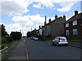
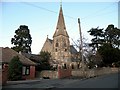
1
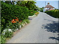
Hermitage Road, Higham
This attractive scene is on the eastern outskirts of Higham.
Image: © Marathon
Taken: 6 Jun 2013
0.10 miles
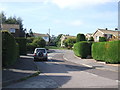
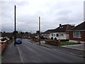
3
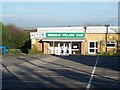
Higham Village Club
On Hermitage Road.
Beside club, footpath leads to School Lane through farmland.
Image: © David Anstiss
Taken: 20 Nov 2008
0.12 miles
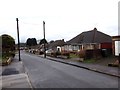
4
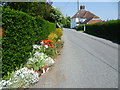
Hermitage Road, Higham
This attractive scene is on the eastern outskirts of Higham, just beyond the built-up area.
Image: © Marathon
Taken: 6 Jun 2013
0.12 miles
10
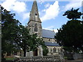
St. John: the parish church of Higham
Image: © Robert Edwards
Taken: 25 Nov 2009
0.21 miles