IMAGES TAKEN NEAR TO
The Braes, ROCHESTER, ME3 7NA
Introduction
This page details the photographs taken nearby to The Braes, ME3 7NA by members of the Geograph project.
The Geograph project started in 2005 with the aim of publishing, organising and preserving representative images for every square kilometre of Great Britain, Ireland and the Isle of Man.

There are currently over 7.5m images from over14,400 individuals and you can help contribute to the project by visiting https://www.geograph.org.uk
Image Map
Images are licensed for reuse under creativecommons.org/licenses/by-sa/2.0
Notes
- Clicking on the map will re-center to the selected point.
- The higher the marker number, the further away the image location is from the centre of the postcode.
Image Listing (61 Images Found)
Images are licensed for reuse under creativecommons.org/licenses/by-sa/2.0
Image
Details
Distance
6
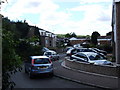
The centre of Higham
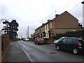
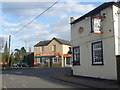
A long way from Lower Higham down on the marshes, and even the area around the railway station, this is the centre of the main part of Higham. This is a crossroads seen from Villa Road, where it meets School Lane, Hermitage Road and Forge Lane. The Gardeners Arms is on the right and the steeple of the new St John's Church is to the left. The old church at Lower Higham can be seen at http://www.geograph.org.uk/photo/48185
Image: © Marathon
Taken: 4 Feb 2013
0.08 miles
7
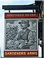
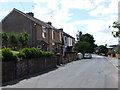
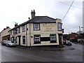
Gardeners Arms - inn sign
For the pub in this 2014 state, see Image
Image: © Robin Webster
Taken: 7 Feb 2014
0.08 miles

10
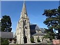
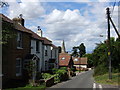
St John's Church, Higham
As the population of Higham almost doubled between 1821 and 1861, the hamlet around St Mary's Church on the edge of the marshes ceased to be the centre of Higham which had gradually moved to the area around the present St John's Church. The Reverend John Hindle, vicar of Higham from 1829 until 1874, was a wealthy man and had St John's and a new vicarage built at his own expense in 1861. The church cost £2,674 and was lit by gaslight until 1957.
A view of the interior can be seen at https://www.geograph.org.uk/photo/6170079
Image: © Marathon
Taken: 25 May 2019
0.08 miles