IMAGES TAKEN NEAR TO
Church Street, ROCHESTER, ME3 7LD
Introduction
This page details the photographs taken nearby to Church Street, ME3 7LD by members of the Geograph project.
The Geograph project started in 2005 with the aim of publishing, organising and preserving representative images for every square kilometre of Great Britain, Ireland and the Isle of Man.

There are currently over 7.5m images from over14,400 individuals and you can help contribute to the project by visiting https://www.geograph.org.uk
Image Map
Images are licensed for reuse under creativecommons.org/licenses/by-sa/2.0
Notes
- Clicking on the map will re-center to the selected point.
- The higher the marker number, the further away the image location is from the centre of the postcode.
Image Listing (97 Images Found)
Images are licensed for reuse under creativecommons.org/licenses/by-sa/2.0
Image
Details
Distance
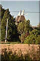
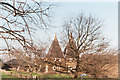
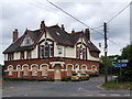
1
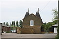
Dairy Farm Oast, Church Street, Higham, Kent
Image: © Oast House Archive
Taken: 29 May 2008
0.01 miles
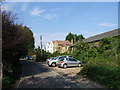
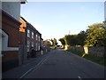
7
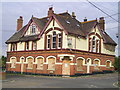
The Chequers Pub, Lower Higham
Church Street, Lower Higham near to The Thames and Medway Canal
Image: © canalandriversidepubs co uk
Taken: 5 Feb 2010
0.08 miles