IMAGES TAKEN NEAR TO
Taylors Lane, ROCHESTER, ME3 7JT
Introduction
This page details the photographs taken nearby to Taylors Lane, ME3 7JT by members of the Geograph project.
The Geograph project started in 2005 with the aim of publishing, organising and preserving representative images for every square kilometre of Great Britain, Ireland and the Isle of Man.

There are currently over 7.5m images from over14,400 individuals and you can help contribute to the project by visiting https://www.geograph.org.uk
Image Map
Images are licensed for reuse under creativecommons.org/licenses/by-sa/2.0
Notes
- Clicking on the map will re-center to the selected point.
- The higher the marker number, the further away the image location is from the centre of the postcode.
Image Listing (9 Images Found)
Images are licensed for reuse under creativecommons.org/licenses/by-sa/2.0
Image
Details
Distance
4
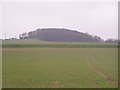
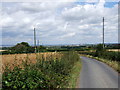
Turk's Hill, Upper Higham
Seen from Lower Road.
Image: © David Anstiss
Taken: 14 Dec 2008
0.12 miles
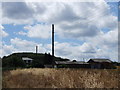
6
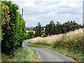
Hill Farm
A farm on Taylors Lane. The name refers to Chilton Hill Image (to the left of the picture).
Image: © Stephen Craven
Taken: 27 Jan 2007
0.12 miles
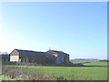
7
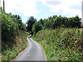
Higham Hall
A large and presumably historic farmstead on Taylors Lane.
Image: © Stephen Craven
Taken: 27 Jan 2007
0.19 miles
8
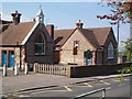
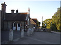
Higham Primary School
Despite the imposing Victorian buildings seen, Higham Primary School has extensive modern buildings at the rear.
Image: © Clive Stanley
Taken: 23 Apr 2004
0.22 miles