IMAGES TAKEN NEAR TO
Canal Road, ROCHESTER, ME3 7HX
Introduction
This page details the photographs taken nearby to Canal Road, ME3 7HX by members of the Geograph project.
The Geograph project started in 2005 with the aim of publishing, organising and preserving representative images for every square kilometre of Great Britain, Ireland and the Isle of Man.

There are currently over 7.5m images from over14,400 individuals and you can help contribute to the project by visiting https://www.geograph.org.uk
Image Map
Images are licensed for reuse under creativecommons.org/licenses/by-sa/2.0
Notes
- Clicking on the map will re-center to the selected point.
- The higher the marker number, the further away the image location is from the centre of the postcode.
Image Listing (36 Images Found)
Images are licensed for reuse under creativecommons.org/licenses/by-sa/2.0
Image
Details
Distance
1
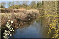
Drainage ditch beside Beckley Hill Works
Image: © David Martin
Taken: 17 Feb 2022
0.02 miles
2
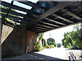
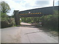
Half a railway bridge, near Lower Higham
Image: © Chris Whippet
Taken: 13 Jul 2009
0.05 miles
5
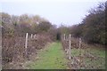
Footpath towards Beckley Hill
This path (No.NS40) leads from Canal Road towards the junction near Beckley Hill and a level crossing. The Mineral railway (from Gravesend to Grain) is behind the bushes on the right.
Image: © David Anstiss
Taken: 30 Oct 2009
0.07 miles
6
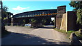
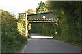
Railway bridge near Higham
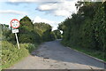
This railway bridge over Canal Road carries freight trains heading to/from the Isle of Grain. Because the bridge is low, vehicles higher than 13'6" are prohibited from passing beneath it.
Image: © Malc McDonald
Taken: 7 Sep 2013
0.07 miles
7
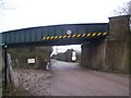
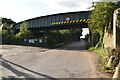
Mineral Railway over Canal Road
Many paths meet here. Canal Road from Lower Higham goes under bridge to railway works at Hoo Junction. Mineral railway heading right leads to Grain from Hoo Junction. Also footpath goes under bridge and then turns right to follow railway to Higham Marshes or Church Street. Also national cycle route goes under bridge from Lower Higham and follows the route of the disused Thames and Medway Canal,left towards Gravesend.
Image: © David Anstiss
Taken: 14 Dec 2008
0.07 miles
8
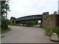
Railway bridge over Canal Road
National Cycle Route 1 towards Gravesend.
Image: © JThomas
Taken: 23 Jun 2022
0.07 miles
10
Railway bridge over Canal Road
This is Canal Road looking back towards Higham. Passenger trains ran on this line from 1882 to 1961, which seems surprising now as it doesn't really serve any significant centres of population. It is still in use by regular container trains on their way via Hoo Junction to and from Thamesport on the Isle of Grain.
Image: © Marathon
Taken: 12 Apr 2011
0.07 miles