IMAGES TAKEN NEAR TO
Grain Road, ME3 0AZ
Introduction
This page details the photographs taken nearby to Grain Road, ME3 0AZ by members of the Geograph project.
The Geograph project started in 2005 with the aim of publishing, organising and preserving representative images for every square kilometre of Great Britain, Ireland and the Isle of Man.

There are currently over 7.5m images from over14,400 individuals and you can help contribute to the project by visiting https://www.geograph.org.uk
Image Map
Images are licensed for reuse under creativecommons.org/licenses/by-sa/2.0
Notes
- Clicking on the map will re-center to the selected point.
- The higher the marker number, the further away the image location is from the centre of the postcode.
Image Listing (28 Images Found)
Images are licensed for reuse under creativecommons.org/licenses/by-sa/2.0
Image
Details
Distance
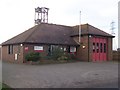
5
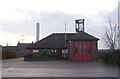
Kent Fire and Rescue Service - Grain
This station is unmanned, and has one fire engine.
Image: © Richard Dorrell
Taken: 22 Dec 2007
0.10 miles
8
Grain Fire Station
On Chapel Road, opposite the High Street.
Image: © David Anstiss
Taken: 28 Dec 2008
0.11 miles