IMAGES TAKEN NEAR TO
Gun Lane, ROCHESTER, ME2 4UL
Introduction
This page details the photographs taken nearby to Gun Lane, ME2 4UL by members of the Geograph project.
The Geograph project started in 2005 with the aim of publishing, organising and preserving representative images for every square kilometre of Great Britain, Ireland and the Isle of Man.

There are currently over 7.5m images from over14,400 individuals and you can help contribute to the project by visiting https://www.geograph.org.uk
Image Map
Images are licensed for reuse under creativecommons.org/licenses/by-sa/2.0
Notes
- Clicking on the map will re-center to the selected point.
- The higher the marker number, the further away the image location is from the centre of the postcode.
Image Listing (138 Images Found)
Images are licensed for reuse under creativecommons.org/licenses/by-sa/2.0
Image
Details
Distance

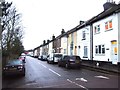
4
Bryant House, Strood
Listed building, former house now used as offices: http://www.britishlistedbuildings.co.uk/en-173201-bryant-house-
Image: © Chris Whippet
Taken: 19 Jan 2014
0.06 miles
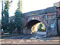
7
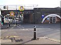
Railway Bridge over Bryant Road
Railway arches on right, contain various small businesses under the Strood to London railway. Bryant Road leads to Gun Lane and Strood town centre.
Image: © David Anstiss
Taken: 19 Nov 2008
0.07 miles
9
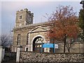
St. Nicholas Church, Strood
On High Street.
In parish of St Nicholas with St Mary.
Currently under repair, hence scaffolding.
Image: © David Anstiss
Taken: 12 Nov 2008
0.08 miles