IMAGES TAKEN NEAR TO
High Street, ROCHESTER, ME2 4TH
Introduction
This page details the photographs taken nearby to High Street, ME2 4TH by members of the Geograph project.
The Geograph project started in 2005 with the aim of publishing, organising and preserving representative images for every square kilometre of Great Britain, Ireland and the Isle of Man.

There are currently over 7.5m images from over14,400 individuals and you can help contribute to the project by visiting https://www.geograph.org.uk
Image Map
Images are licensed for reuse under creativecommons.org/licenses/by-sa/2.0
Notes
- Clicking on the map will re-center to the selected point.
- The higher the marker number, the further away the image location is from the centre of the postcode.
Image Listing (145 Images Found)
Images are licensed for reuse under creativecommons.org/licenses/by-sa/2.0
Image
Details
Distance
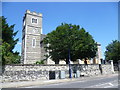
2
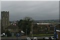
Strood church from the train, on a dark November day
Just visible to the right of the church, on the far side of the river, is Rochester Cathedral.
Image: © Christopher Hilton
Taken: 26 Nov 2018
0.02 miles
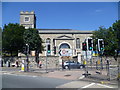
4
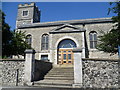
St Nicholas with St Mary Church, Strood
With the M2 by-passing Strood coupled with the one-way system in the town centre, it is easy to forget that St Nicholas with St Mary Church is on the ancient Watling Street between London, Canterbury and Dover. The tower is medieval and the church itself dates from 1812. It is not easy to photograph as it is right on the junction of the A2 (High Street) and A228 (Commercial Road).
Image: © Marathon
Taken: 24 Jul 2013
0.04 miles
5
St Nicholas with St Mary Church, Strood
With the M2 by-passing Strood coupled with the one-way system in the town centre, it is easy to forget that St Nicholas with St Mary Church is on the ancient Watling Street between London, Canterbury and Dover. The tower is medieval and the church itself dates from 1812. It is not easy to photograph as it is right on the junction of the A2 (High Street) and A228 (Commercial Road).
Image: © Marathon
Taken: 24 Jul 2013
0.04 miles
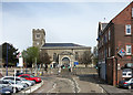
6
St Nicholas with St Mary Church, Strood
With the M2 by-passing Strood coupled with the one-way system in the town centre, it is easy to forget that St Nicholas with St Mary Church is on the ancient Watling Street between London, Canterbury and Dover. The tower is medieval and the church itself dates from 1812. It is not easy to photograph as it is right on the junction of the A2 (High Street) and A228 (Commercial Road). This view is from Commercial Road.
Image: © Marathon
Taken: 24 Jul 2013
0.04 miles
7
St Nicholas's Church, Strood
At the junction of High Street and Commercial Road.
Image: © Des Blenkinsopp
Taken: 21 Apr 2016
0.04 miles
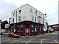
8
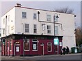
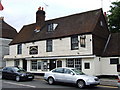
Bull's Head Public House, Strood
On junction of London Road and Gun Lane.
Image: © David Anstiss
Taken: 12 Nov 2008
0.04 miles
9
Crispin and Crispianus, London Road, Strood
Image: © Chris Whippet
Taken: 17 Jun 2009
0.04 miles
10
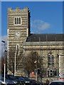
St Nicholas Church Clock Tower, Strood
On High Street (A2), taken from Commercial Road.
Currently undergoing repair work.
Image: © David Anstiss
Taken: 11 Nov 2008
0.04 miles