IMAGES TAKEN NEAR TO
Basi Close, ROCHESTER, ME2 4RF
Introduction
This page details the photographs taken nearby to Basi Close, ME2 4RF by members of the Geograph project.
The Geograph project started in 2005 with the aim of publishing, organising and preserving representative images for every square kilometre of Great Britain, Ireland and the Isle of Man.

There are currently over 7.5m images from over14,400 individuals and you can help contribute to the project by visiting https://www.geograph.org.uk
Image Map
Images are licensed for reuse under creativecommons.org/licenses/by-sa/2.0
Notes
- Clicking on the map will re-center to the selected point.
- The higher the marker number, the further away the image location is from the centre of the postcode.
Image Listing (55 Images Found)
Images are licensed for reuse under creativecommons.org/licenses/by-sa/2.0
Image
Details
Distance
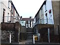
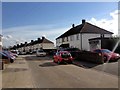
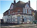
2
Powlett Road, Frindsbury
Near Cooling Road
Image: © Danny P Robinson
Taken: 13 Jul 2008
0.05 miles
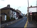
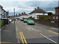
6
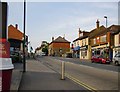
The A228 at Frindsbury: view north-east
View uphill from the filling-station at the corner of Bell Street Road (there's a good Kentish name for you).
The A228 leads out to the Hoo peninsula and Grain.
Image: © Stefan Czapski
Taken: 28 May 2016
0.06 miles
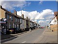
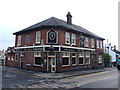
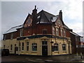
10
The Ship Public House, Frindsbury
On junction of Bill Street and Bingham Road. Closed for redevelopment.
Image: © David Anstiss
Taken: 19 Nov 2008
0.07 miles