IMAGES TAKEN NEAR TO
St. Marys Road, ROCHESTER, ME2 4GF
Introduction
This page details the photographs taken nearby to St. Marys Road, ME2 4GF by members of the Geograph project.
The Geograph project started in 2005 with the aim of publishing, organising and preserving representative images for every square kilometre of Great Britain, Ireland and the Isle of Man.

There are currently over 7.5m images from over14,400 individuals and you can help contribute to the project by visiting https://www.geograph.org.uk
Image Map
Images are licensed for reuse under creativecommons.org/licenses/by-sa/2.0
Notes
- Clicking on the map will re-center to the selected point.
- The higher the marker number, the further away the image location is from the centre of the postcode.
Image Listing (171 Images Found)
Images are licensed for reuse under creativecommons.org/licenses/by-sa/2.0
Image
Details
Distance
4
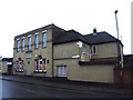
Strood and Frindsbury Workmen's Club and Institute
Image: © Chris Whippet
Taken: 15 Dec 2013
0.04 miles
5
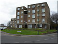
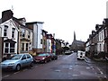
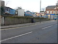
Aveling Court, North Street, Strood
Photo taken from North Street.
Image: © Danny P Robinson
Taken: 2 Mar 2008
0.04 miles
7
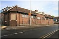
1925 Rochester & District Cooperative Industrial Society Dairy
Old Co-Op Dairy on the corner of Frindsbury Road and Wykeham Street, Strood.
The building hasn't been a dairy for some time. It's unusual to see the original signage as this is normally covered up with signage advertising the current occupant.
Sadly, the lettering has been damaged.
Image: © Richard Gadsby
Taken: 16 May 2021
0.05 miles
8
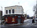
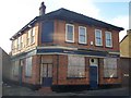
Tug & Shovel, Strood
This public house has been boarded up for almost ten years. It now looks like it is finally going to be demolished and replaced with flats.
Image: © Chris Whippet
Taken: 18 May 2016
0.05 miles
9
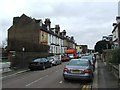
Site of former Tug and Shovel, 65, North Street, Strood
Planning permission has been approved, with conditions, by Medway Council under application number MC/14/3241 for an “application for non-material amendment to planning permission MC/14/1793 (demolition of existing public house and construction of a part three storey/part four storey building with undercroft car parking court to create 8 two bedroomed flats together with bin and cycle storage) to amend site boundary and alterations to parking layout”. Chris Whippet photographed the Image before it was demolished.
Image: © John Baker
Taken: 14 Feb 2017
0.05 miles
10
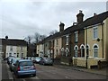
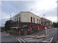
The Red Lion Public House, Strood
On junction of Frindsbury Road and Cliffe Road.
Closed, probably due to too much competition...
Image: © David Anstiss
Taken: 19 Nov 2008
0.05 miles