IMAGES TAKEN NEAR TO
Grange Road, ROCHESTER, ME2 4DA
Introduction
This page details the photographs taken nearby to Grange Road, ME2 4DA by members of the Geograph project.
The Geograph project started in 2005 with the aim of publishing, organising and preserving representative images for every square kilometre of Great Britain, Ireland and the Isle of Man.

There are currently over 7.5m images from over14,400 individuals and you can help contribute to the project by visiting https://www.geograph.org.uk
Image Map
Images are licensed for reuse under creativecommons.org/licenses/by-sa/2.0
Notes
- Clicking on the map will re-center to the selected point.
- The higher the marker number, the further away the image location is from the centre of the postcode.
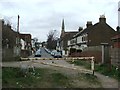
Image Listing (200 Images Found)
Images are licensed for reuse under creativecommons.org/licenses/by-sa/2.0
Image
Details
Distance
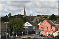
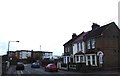
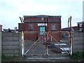
2
Grove Road, Strood
At the crossroads with Grange Road.
Image: © Danny P Robinson
Taken: 2 Mar 2008
0.02 miles
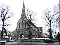
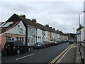
8
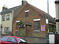
Church on Grange Road, Strood
It doesn't state what denomination it is, so I guess it is an independent church. The board over the door gives service times.
Image: © Danny P Robinson
Taken: 2 Mar 2008
0.04 miles