IMAGES TAKEN NEAR TO
High Street, ROCHESTER, ME2 4AH
Introduction
This page details the photographs taken nearby to High Street, ME2 4AH by members of the Geograph project.
The Geograph project started in 2005 with the aim of publishing, organising and preserving representative images for every square kilometre of Great Britain, Ireland and the Isle of Man.

There are currently over 7.5m images from over14,400 individuals and you can help contribute to the project by visiting https://www.geograph.org.uk
Image Map
Images are licensed for reuse under creativecommons.org/licenses/by-sa/2.0
Notes
- Clicking on the map will re-center to the selected point.
- The higher the marker number, the further away the image location is from the centre of the postcode.
Image Listing (258 Images Found)
Images are licensed for reuse under creativecommons.org/licenses/by-sa/2.0
Image
Details
Distance
1
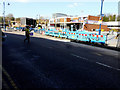
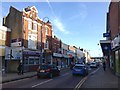
Relaying the pavement
Along Strood’s High Street.
Image: © John Baker
Taken: 24 Mar 2019
0.01 miles
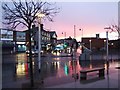
2
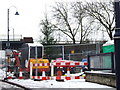
Christmas tree, Strood
The poor tree is surrounded by roadworks.
Image: © Chris Whippet
Taken: 21 Dec 2009
0.02 miles
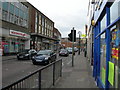
6
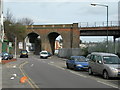
Station Road, Strood
Looking towards the railway bridge that carries the London to Faversham line over the road.
Image: © Danny P Robinson
Taken: 2 Mar 2008
0.04 miles
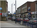
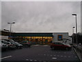
7
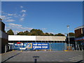
New Strood Aldi
As seen from the A228 High Street.
Image: © David Anstiss
Taken: 14 Oct 2012
0.04 miles
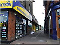
10
Aldi, Strood
Newly opened budget supermarket on Friary Place.
Image: © David Anstiss
Taken: 24 Dec 2012
0.05 miles