IMAGES TAKEN NEAR TO
Watling Street, ROCHESTER, ME2 3UQ
Introduction
This page details the photographs taken nearby to Watling Street, ME2 3UQ by members of the Geograph project.
The Geograph project started in 2005 with the aim of publishing, organising and preserving representative images for every square kilometre of Great Britain, Ireland and the Isle of Man.

There are currently over 7.5m images from over14,400 individuals and you can help contribute to the project by visiting https://www.geograph.org.uk
Image Map
Images are licensed for reuse under creativecommons.org/licenses/by-sa/2.0
Notes
- Clicking on the map will re-center to the selected point.
- The higher the marker number, the further away the image location is from the centre of the postcode.
Image Listing (19 Images Found)
Images are licensed for reuse under creativecommons.org/licenses/by-sa/2.0
Image
Details
Distance
1
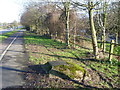
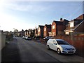
Watling Street
Watling Street was the original Roman road between London, Canterbury and Dover. It is now by-passed by the M2. This is the view along the edge of Watling Street looking in the direction of Strood and Rochester. The turn to the right is for Parkfields and the parallel road named The Shades is just beyond the trees on the right.
Image: © Marathon
Taken: 14 Feb 2013
0.05 miles
2
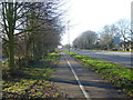
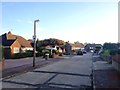
Watling Street, Strood
Watling Street was the original Roman road between London, Canterbury and Dover. It is now by-passed by the M2. This is the view along the edge of Watling Street looking in the direction of Dartford and London. The dual carriageway A2 is joined about a mile ahead. The parallel road named The Shades is just beyond the trees on the left.
Image: © Marathon
Taken: 14 Feb 2013
0.05 miles
6
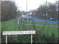
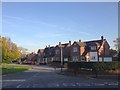
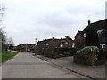
Old Watling Street, Strood
Watling Street is the historic name for the London-Rochester Road which follows the old Roman route. Since the building of the M2 and A289 trunk road it is quieter.
Image: © Stephen Craven
Taken: 27 Jan 2007
0.11 miles

9
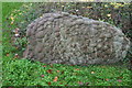
Sarsen stone, Old Watling Street, Strood
This stone and another stand near the corner of Old Watling Street and the A1. Sarsens were formed in Miocene times by a process of siliceous cementation within pre-existing strata of fine quartz sandstones. Whereas the sandstones were in due course eroded, the much harder sarsens have survived and are still to be seen in North Kent and in many other parts of south-east England. The matter of how this stone acquired its smoothly rounded, convex surfaces remains unresolved. Were existing mamillary concretions cemented together to form the configuration seen here or was the latter the product of a single episode of cementation?
Image: © David Kemp
Taken: 8 Nov 2015
0.17 miles